Friday, July 29, 2011

FTJ, Entry 104: Gorging on the Columbia

The Columbia River Gorge, which separates the states of Oregon and Washington, is a spectacular wonder of nature. We stayed there three nights, in White Salmon, WA. Another wow wow wow place. (Not White Salmon, which was a dot on the map, but the gorge itself.) Would not want to live here, but for the once-in-a-lifetime experience, coming here was well worth the trip. 

The gorge is the only sea level passage through the Cascade Mountain range. The sides of the gorge rise more than 4,000 feet from river level. Volcanic eruptions laid down lava beds that were then scoured out by torrents of water up to 2,000 feet deep, released when ice-dams burst further upstream  to form the cliffs on either side. Experts say one big burst 18,000 years ago released 500 million cubic miles of water! These ice-dam bursts apparently happened frequently as the glaciers advanced and retreated during the Ice Ages.

Although I tried to get a great photo of the gorge from a central spot, I failed. So I include these two stock photos to give you a good view of the natural beauty we saw there:

The area known as Cape Horn.


 Okay, no more "fake photos."  Here are some we took.

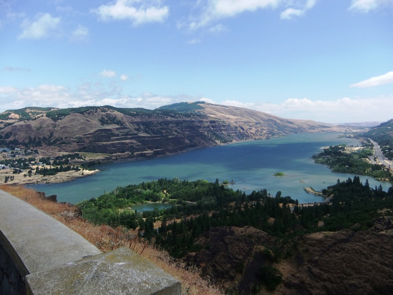
OOPS -- I lied! I did get a good shot of the gorge from overhead, on our trip up to the Rowena Loops.
Beau checks out the "Loops" from an overlook.

A good view of part of the Rowena Loops.

The views were truly breathtaking.

The Rowena Loops, built in the early 1900s, were one of the first modern paved roads in the Pacific Northwest, winding through rugged landscape up from sea level to dizzying heights above the Columbia River. They were carefully designed by engineer John A. Elliott, to echo the natural turns and grades of the gorge cliffs themselves.

Here is a great quote from him (1929) we saw on one of the overlooks:

Grades, curvatures, distance, and even expense were sacrificed to reach some scenic vista or to develop a particularly interesting spot.... Although the highway would have commercial value in connecting the coast with the eastern areas, no consideration was given the commercial over the scenic requirements. The one prevailing idea in the location and construction was to make this highway a great scenic boulevard surpassing all other highways in the world.

They did a helluva job.

Beyond the loops area, there were great views on both sides of the gorge. It didn't really matter where you drove along the gorge -- the scenery was continually spectacular.


I stitched two photos together to show you the view from the Memaloose Overlook. The tiny island to the right is where the Indians traditionally buried their dead.

Here and below, typical views of the gorge cliffs.


The Columbia River Gorge is also world renowned for kite boarding and windsurfing. From the bridge between the two states over the gorge, the myriad multicolor sails look like butterflies.


A lone windsurfer getting a great ride. The winds are about 25 knots, maybe 30 on a typical day.

We went down to the shore to check out the action. The kite boarders were skimming right up alongside the shore. They were flying!


To the Timberline

Our ride up Mount Hood (Beau wanted to get a closer look at the behemoth) took us through virgin forests, along the Hood River, and past a number of waterfalls. Our last stop was the Timberline Lodge. The lodge is located at an elevation of 6,000 feet (Mount Hood is almost a mile higher -- 11,245 feet). The snow depth average at Timberline is TWENTY ONE FEET!!!

The Hood River.


The lodge is a national historic landmark.

When we went to the Timberline Lodge, we were surprised to see skiers and snowboarders. On July 25th. So you can "board" both at sea level and up on the mountain. For the athletes, this area must be Mecca.

Skiers, climbers, boarders ascend to descend.
The lodge was built in 1936, with construction taking about a year. It was a WPA project. You wonder how the heck they got all the supplies and equipment way the heck UP here, way back when.

Part of the Timberline lobby.
    

This is the closest we got to the top of Mount Hood. Spectacular!

Dam Dam Dam

We did a lot here in the gorge area. Our travels also took us to one of the river's dams. (There are lots of dams on the Columbia. But we saw only one, at a place called The Dalles.)


These are "fish ladders" to help the salmon and other fish swim upstream past the dam.

The 1 and 1/2 mile long dam has 22 generating units, capable of producing 1.8 million kilowatts of power -- they say that's enough to power 800,000 homes.

Stonehenge, American Style

I saw some tourist information promoting Stonehenge, a memorial to WWI soldiers lost in battle. Had to go -- another oddity for the blog!
Wow it was windy up there. But it was very cool to see -- and moving. Inside the memorial are plaques with the names of those lost during the war.

This American Stonehenge, built by Samuel Hill in 1929, is dedicated to 13 men of Klickitat County who died during World War I. Apparently, Hill saw the ancient Stonehenge in England and was told it was used for human sacrifices to pagan gods (the sacrifice story was later generally discredited). Anyway, he was inspired to create another such monument, in that he believed the "flower of humanity is still being sacrificed to the god of war on fields of battle."

Whatever, it is a cool structure and a nice tribute to fallen young men.

We left the gorge area and traveled next to Long Beach, WA, the end of the friggin' world, we discovered. More on that next time.

I'll end this with photos of four of the many tunnels we had to go through on our way north. Gulp!

Lots of dings and scrapes on these tunnel entrances and walls!! None from us, fortunately.

Tanks, Panky

Tuesday, July 26, 2011

FTJ, Entry 103: Coasting North for Cheese

I should have written this months ago -- to our followers and friends, there will be no hard feelings AT ALL if any of you would like to opt out of these emails/blog entries. Totally understandable. I am getting bored myself with these never-ending travelogues! Please let me know if you would like to come off the list and just check our blog online when YOU feel like it.

For the remaining victims, here is another overly long update.

So we bopped north up the coast from Newport, OR, visiting Depoe Bay, Cape Kiwanda, Lincoln City, and Tillamook, among other places. I really wanted to get to Tillamook to see the famous cheese factory. 

The sights along the way were, as usual, beautiful. 

Depoe Bay, the world's smallest harbor.

Outside the Depoe Bay Whale Center -- many people sight whales off the shore here, but we didn't get lucky.
 
Haystack Rock, Cape Kiwanda.
 

Those little dots on the giant dune at Cape Kiwanda are people sliding down the side, with sand boards and without. It looks like fun -- except for the climb UP. That blue bird flying above the grass is a kite.
 
Cape Foulweather was a must for Beau. It is aptly named.
As the sign says, it can indeed get foul here, with wind speeds as high as 100 mph at times. This is the replacement sign -- the old one blew away!!


The sea was calm this day, lucky for us. What a view!


The Cape Foulweather Gift Shop. They have moose here...

...as you can see. Bullwinkle looks so darned cute.

Cheese Ho!

After I wrote this subhead, I thought, "Gee, I meant to create a play on words with the saying, 'land ho,' but now I see that this could be read an entirely different way."  Had to chuckle myself. I do love cheese, but I am not sure I would do THAT for it.

We did get to some cheese shops -- among them, the Blue Heron French Cheese Company, which is a misnomer, in that it is really a country store with some cheese, among other gourmet items.

At the Blue Heron we saw a very good looking ass.

Hee Hawwww! A true Republican.
Entertainment while you shop.
Finally, the Tillamook Cheese factory.

They had cheese sampling, but unfortunately the factory does not run on Saturday.
I had no idea that Tillamook's cheddar is the 2nd most popular chunk cheddar in the country. Here is where they process it.


Oddity Sightings

You know I love the oddities. Here are just two (besides the previously shown moose and jackass).


Li'l Sambo's Restaurant, Lincoln City. I thought the book Little Black Sambo was now considered racist...apparently not here. They did leave out the "Black," though, which was probably a good decision. 
A weird wood carving store. The wooden cowboy, far left, looks like he has to pee, doesn't he?

Farewell, Newport

Two of our last Newport sunsets...


...over the vast Pacific.


Of course I am behind again. We are just finishing up our three-night stay in White Salmon, Washington. We "camped" in the middle of the Columbia River Gorge area, right along the river itself. What an incredibly gorgeous place. More on that next time, including photos of Stonehenge.

For now, check out the grandeur of Mount Hood. You go around the corner from our RV campground and boom! There it is in the distance across the river. WOW.


Tanks, Panky


Thursday, July 21, 2011

FTJ, Entry 102: The Deepest Lake, the Biggest Skeeters

We only stayed one night in the Crater Lake area. It was rainy and cold and the mosquitoes were the size of B-52s. Also, the nearest grocery store or RV service facility was at least 60 miles away. I hated the RV park, which was actually perfectly fine, but was in the middle of  #$%!! nowhere. Moreover,  it didn't have cable TV. Or any kind of antenna TV. Come on!!

Beau and I have decided that we are not really "campers." (I am sure many of our friends are laughing right now. As if we ever thought of ourselves as campers to begin with!) Anyway, we would describe ourselves as "travelers who like visiting luxury RV resorts in populated areas"!

Anyhoooo, knowing we were leaving the next day, we spent some time exploring Crater Lake National Park in the late afternoon. What we found was quite amazing and surprising. Idiot that I am, I expected both our campground (Diamond Lake RV Park) and Crater Lake itself to be touristy lake destinations. HAHAHAHA. Umm, NO! This is the wilderness, baby. A wilderness at 6,000+ feet, with huge snowdrifts and temperatures in the 40s in mid July. 

YES, you read that correctly: TEMPS IN THE 40s.

Here is our dusty car thermometer to prove it:


A sample of the snow remaining in the park. That pile is about 20 ft. high!
Hey hon, let's spend the summer at Crater Lake! And there will be lots for the kids to do...
...like sledding!
 

Anyway, about the lake itself. Stunning.  Astounding.

Formed by the collapse of a volcano called Mt. Mazama 7,700 years ago, the lake is basically a big caldera. It is 5 miles wide and ringed by cliffs almost 2,000 feet high. It is the deepest lake in the United States, at 1,943 feet. Later volcanic eruptions formed a small peak in Crater Lake called Wizard Island, shown in several of the photos below.
 
Note Wizard Island, the "mini volcano."


We were unprepared for the cold weather.


Nice road, huh? Guardrails are pretty much just a fantasy.

We came, we saw the lake, and I said to Beau, "Get me the hell outta here."  Ah, nature!

We are now ensconced in a beautiful luxury RV park in Newport, Oregon, with a terrific view of the Pacific Ocean right out the windshield.  

Now THIS is my idea of camping! When we got here, the sky was blue and temps were about 70. YAY!


We get to enjoy a fire right at our table in the evening. And we don't even have to scavenge wood.
Dinner by the ocean.
 
The beach right below our RV site.

The storms scoured out the coastline here, and many of the
access stairways have been washed away, leaving steep cliffs above the beach.

We rappelled down the cliffs to get to the beach below. (OK, maybe not this particular cliff, and maybe we did not rappel, but we had to go down a cliff nonetheless.)


You can see the damage done by the recent storms. These homeowners must be a bit worried!

I think we are both very grateful to be back in civilization again, at least temporarily. 

AND I FINALLY CAUGHT UP ON THIS BLOG!!!!  for now....

More on Newport in the next entry. We are here through the weekend.

Our best to all,

Tanks, Panky